
 NATIONAL WATER QUALITY MONITORING COUNCIL
WQP Web Services Guide
Introduction
The Water Quality Data Portal (WQP) provides easy access to data stored in three large water quality databases (WQX, NWIS) through a web-based form interface as well as standalone web services. Both the form interface and the web services use the same input parameters (filters) and produce the same output formats. The web service enables programmatic access to WQP data and metadata without manually interacting with the form interface.
You can use the WQP web services to quickly and easily access data and metadata available on the Water Quality Portal. URL queries are constructed in a standard format and outputs are delivered in a number of user-defined formats.
For more information on the WQP input parameters (filters) and data downloads, see the WQP User Guide.
What Are Web Services?
APIs (Application Programming Interface) and Web Services are tools that enable communication between two networked devices or pieces of software using standardized methods. They are implemented in almost all of our mobile device applications that we use on a daily basis. They allow data from one system to be easily used by a second system without requiring the second system to locally store the data, which is especially beneficial when we are dealing with big data sets. In fact, common software packages including Excel and R are starting to come pre-packaged with the ability to use these services.
While APIs and Web Services provide similar functions, the types of communication they allow differs:
-
An API allows two applications to communicate by creating shared rules and conventions. These can be used with a network connection, but there are also APIs that do not involve a network connection.
-
A web service is a type of API that allows one computer to communicate data to another computer in a standardized way. While all web services are APIs, not all API's are web services.
The WQP web services are implemented using the 'https' protocol using REST, which provides a flexible and scalable approach for constructing standardized URL statements.
Click here to learn more about the basics of APIs, or check out this Github page for details about how APIs are implemented within the USGS and across the federal government.
Accessing Data Programmatically Through Web Services
Web services provide a public resource which users can also enhance with their own custom scripts.
One resource created by the USGS is an R-based software package called dataRetrieval, which makes it easier for R users to use the WQP web services. dataRetrieval does the heavy lifting to download data and convert it into a familiar and usable format. dataRetrevial can download data from the WQP and from a number of USGS NWIS services. To learn more about dataRetrieval, please check out these resources:
- CRAN - Download current release
- GitHub - Download most up-to-date source code (may contain bugs)
- Tutorial - Learn how to use dataRetrieval
How to Generate Web Services Requests
You can retrieve the same data using Web Services that you can with the WQP User Interface (advanced form). Query basics are outlined in the following series of tables. Most non-alphanumeric characters (such as punctuation) must be "url-encoded", (for example: space is "%20").
Constructing a Request:
Every request starts with a base URL: the base URL will vary depending on the type of information requested:
- Base URL for downloading project data:
https://www.waterqualitydata.us/data/Project/search? - Base URL for downloading site data and associated metadata:
https://www.waterqualitydata.us/data/Station/search? - Base URL for downloading results:
https://www.waterqualitydata.us/data/Result/search? - Base URL for downloading result detection quantitation limit data:
https://www.waterqualitydata.us/data/ResultDetectionQuantitationLimit/search? - Base URL for downloading activity data:
https://www.waterqualitydata.us/data/Activity/search? - Base URL for downloading activity metric data:
https://www.waterqualitydata.us/data/ActivityMetric/search? - Base URL for downloading biological metric data:
https://www.waterqualitydata.us/data/BiologicalMetric/search? - Base URL for downloading project monitoring location weighting data:
https://www.waterqualitydata.us/data/ProjectMonitoringLocationWeighting/search?
Construct a query by concatenating the base URL with the desired parameters and arguments,as shown in Table 1. At least one parameter-argument pair must be specified. Separate multiple parameter-argument pairs with an ampersand ("&"). For downloads, if no file format (mime type) is specified, the retrieval will default to WQX-XML format. See the WQP User Guide for a list of elements included in the result retrievals.
Table 1. URL-encoded retrieval parameters and arguments for WQP web services (parameter names are case-insensitive only to the leading capital letter)
Expand Table
| REST parameter | Argument | Discussion |
|---|---|---|
| bBox | Western-most longitude, Southern-most latitude, Eastern-most longitude, and Northern-most longitudeseparated by commas, expressed in decimal degrees, WGS84, and longitudes west of Greenwich are negative. (Example: bBox=-92.8,44.2,-88.9,46.0) | These four arguments are used together to form a quadrant of the Earth's surface for locating data-collection stations. Many stations outside the continental US do not have latitude and longitude referenced to WGS84 and therefore cannot be found using these parameters. Other stations are not associated with latitude and longitude due to Homeland Security concerns. |
| lat | Latitude for radial search, expressed in decimal degrees, WGS84 | These three arguments are used together to form a circle on the Earth's surface for locating data-collection stations. Many stations outside the continental US do not have latitude and longitude referenced to WGS84 and therefore cannot be found using these parameters. |
| long | Longitude for radial search, expressed in decimal degrees, WGS84 | |
| within | Distance for radial search, expressed in decimal miles | |
| countrycode | Two-character Federal Information Processing Standard (FIPS) country code. | FIPS country codes were established by the National Institute of Standards, publication 10-4. |
| statecode | *Two-character Federal Information Processing Standard (FIPS) country code, followed by a URL-encoded colon ("%3A"), followed by a two-digit FIPS state code. * | FIPS state codes were established by the National Institute of Standards, publication 5-2. |
| countycode | *Two-character Federal Information Processing Standard (FIPS) country code, followed by a URL-encoded colon ("%3A"), followed by a two-digit FIPS state code, followed by a URL-encoded colon ("%3A"), followed by a three-digit FIPS county code. * | FIPS county codes were established by the National Institute of Standards, publication 6-4. |
| siteType | One or more case-sensitive site types, separated by semicolons. | Restrict retrieval to stations with specified site type (location in the hydrologic cycle). The MonitoringLocationTypeName for individual records may provide more detailed information about the type of individual stations. |
| organization | For USGS organization IDs, append an upper-case postal-service state abbreviation to "USGS-" to identify the USGS office managing the data collection station records. However, a few US states are serviced by one USGS office. (USGS-MA = Massachusetts and Rhode Island, USGS-MD = Maryland, Delaware, and the District of Columbia, USGS-PR = Caribbean Islands, USGS-HI = Pacific Islands). | USGS offices sometimes provide data for stations outside the political boundaries associated with the office's organization code. Use the statecode or countycode arguments to search for stations located within those political boundaries. |
| siteid | Concatenate an agency code, a hyphen ("-"), and a site-identification number. | Each data collection station is assigned a unique site-identification number. Other agencies often use different site identification numbers for the same stations. |
| huc | One or more eight-digit hydrologic units, delimited by semicolons. | Hydrologic unit codes identify surface watersheds. The lists and maps of hydrologic units are available from USGS. |
| sampleMedia | One or more case-sensitive sample media, separated by semicolons. | Sample media are broad general classes, and may be subdivided in the retrieved data. Examine the data elements ActivityMediaName, ActivityMediaSubdivisionName, and ResultSampleFractionText for more detailed information. |
| characteristicType | One or more case-sensitive characteristic types (groupings) separated by semicolons. | These groups will be expanded as part of the ongoing collaboration between USGS and USEPA. |
| characteristicName | One or more case-sensitive characteristic names, separated by semicolons. | Characteristic names identify different types of environmental measurements. The names are derived from the USEPA Substance Registry System (SRS). USGS uses parameter codes for the same purpose and has associated most parameters to SRS names. |
| pCode | One or more five-digit USGS parameter codes, separated by semicolons. | |
| activityId | One or more case-sensitive activity IDs, separated by semicolons. | Designator that uniquely identifies an activity within an organization. |
| startDateLo | Date of earliest desired data-collection activity, expressed as MM-DD-YYYY | These two parameters, used together or individually, restrict the retrieval to data-collection activities within a range of dates. |
| startDateHi | Date of last desired data-collection activity, expressed as MM-DD-YYYY | |
| mimeType | xml | Output format is XML compatible with WQX-Outbound schema. This is the default format, and if a mimeType is not specified, the data will be in XML format. |
| xlsx | Output format is xlsx compatible with MS-Excel 2007 and greater. | |
| csv | Output format is comma-separated columns. | |
| tsv|tab | Output format is tab-separated columns. | |
| geojson | Output format is GeoJSON (JavaScript Object Notation). | |
| kml | Output format is KML compatible with Google Earth. This option is not available for the results service. | |
| kmz | Output format is kmz, a compressed form of kml compatible with Google Earth. This option is not available for the results service. | |
| Zip | yes | Include the parameter to stream compressed data. Compression often greatly increases throughput, thus expediting the request. Kml files will be returned in the kml-specific zip format, .kmz. |
| providers | *EPA|NWIS* | By default, requests are submitted to all the data providers. However, a particular provider may be specified using this parameter. |
| sorted | yes|no | By default, tabular data are sorted by organization, monitoringLocationID, and (for results) activityID. However, sorting increases response time significantly, sometimes by orders of magnitude. If you are doing your own sorting after download, set sorted=no. For large downloads (over 5 million rows) sorting is disabled by default to ensure reasonable response times. XML requests are always sorted to accommodate the WQX data schema. |
| dataProfile | biological | Only affects results endpoint at this time. The biological dataProfile returns an extended set of columns that further describe biological data. |
Example Web Service Requests
To try out the following examples of REST web service requests, copy and paste into a web browser.
Example: REST web service request to retrieve sites from Oklahoma County, Oklahoma, where Atrazine was measured in XML format, zipped:
https://www.waterqualitydata.us/data/Station/search?countycode=US%3A40%3A109&characteristicName=Atrazine&mimeType=xml&zip=yes
Example: REST web service request to retrieve sites contained within a bounding box where Caffeine was measured in KML format, zipped:
https://www.waterqualitydata.us/data/Station/search?characteristicName=Caffeine&mimeType=kml&bBox=-92.8,44.2,-88.9,46.0&zip=yes
Example: REST web service request to retrieve stream sites located in the state of Wyoming (USA) where parameters of the characteristicType Nutrient were measured, in GeoJSON format:
https://www.waterqualitydata.us/data/Station/search?countrycode=US&statecode=US%3A56&siteType=Stream&characteristicType=Nutrient&mimeType=geojson
Example: REST web service request to retrieve Caffeine sample results from sites contained within a bounding box and collected on, or after, 10-01-2006 in MS-Excel format, zipped:
https://www.waterqualitydata.us/data/Result/search?characteristicName=Caffeine&bBox=-92.8,44.2,-88.9,46.0&startDateLo=10-01-2006&mimeType=xlsx&zip=yes
Queries Using POST
In certain situations when very long requests are submitted - for example, when querying data for a large list of sites - GET requests can fail due to limits in the allowable length of the request. These requests can instead be completed using http POST. POST requests should be submitted with a JSON-formatted payload.
Here's an example JSON object, including an organization ID and three site ID's:
{
"organization": ["WIDNR_WQX"],
"siteid": ["WIDNR_WQX-133003", "WIDNR_WQX-133398", "WIDNR_WQX-133486"]
}
An example using curl with these data looks like this:
curl -X POST --header 'Content-Type: application/json' --header 'Accept: application/zip' -d '{"organization":["WIDNR_WQX"],"siteid":["WIDNR_WQX-133003","WIDNR_WQX-133398","WIDNR_WQX-133486"]} \
 ' 'https://www.waterqualitydata.us/data/Station/search?mimeType=csv&zip=yes'
The --header argument lists metadata for the web service and ensures that the correct information is received and returned. If there are any problems with the request, they are returned in the response via the warning header(s). See RFC 2616 Section 14 for the format of the warning header.
Retrieving Summary Data Using the WQP Summary Web Service
Among the web service offerings is also a summary service, which enables users to obtain summary-level information on a data set of interest. This can be useful for evaluating the number and types of data available for particular sites or date ranges. It can also make it quicker and easier to generate summary tables for reports and publications.
- Base URL for the summary service:
https://www.waterqualitydata.us/data/summary/monitoringLocation/search?
There are two main types of downloads based on the dataProfile selected: periodOfRecord or summaryMonitoringLocation.
-
periodOfRecord: For the queried sites and specific period of record, provides site-level organization and spatial data and annual summaries of total # results (equivalent to total number of records) and total # activities (equivalent to total number of collection events) for each queried characteristicName (i.e. water quality measurement).
-
summaryMonitoringLocation: For the queried sites and specific period of record, provides site-level organization and spatial data and the total # results (equivalent to total number of records) and total # activities (equivalent to total number of collection events) for all queried characteristicName's combined. Output is in a GeoJSON format only: be sure to specify mimeType=geojson in these queries.
Construct a query by concatenating the base URL with the desired parameters and arguments,as shown in Table 2. At least one parameter-argument pair is required. Separate multiple parameter-argument pairs with an ampersand ("&"). For downloads, if no file format (mime type) is specified, the retrieval will default to .csv format.
Example: Summary service request to retrieve annual summary counts from the most recent 5 years of Nutrient data from sites in Benton County, Arkansas in csv format, zipped:
https://www.waterqualitydata.us/data/summary/monitoringLocation/search?countycode=US%3A05%3A007&characteristicType=Nutrient&mimeType=csv&zip=yes&dataProfile=periodOfRecord&summaryYears=5
Example: Summary service request to retrieve total counts from the most recent 5 years of Nutrient data from sites in Benton County, Arkansas in GeoJSON format, zipped:
https://www.waterqualitydata.us/data/summary/monitoringLocation/search?countycode=US%3A05%3A007&characteristicType=Nutrient&zip=yes&dataProfile=summaryMonitoringLocation&summaryYears=5&mimeType=geojson
Table 2. URL-encoded retrieval parameters and arguments for WQP web services.
Expand Table
| REST parameter | Argument | Discussion |
|---|---|---|
| bBox | Western-most longitude, Southern-most latitude, Eastern-most longitude, and Northern-most longitudeseparated by commas, expressed in decimal degrees, WGS84, and longitudes west of Greenwich are negative. (Example: bBox=-92.8,44.2,-88.9,46.0) | These four arguments are used together to form a quadrant of the Earth's surface for locating data-collection stations. Many stations outside the continental US do not have latitude and longitude referenced to WGS84 and therefore cannot be found using these parameters. Other stations are not associated with latitude and longitude due to Homeland Security concerns. |
| characteristicName | One or more case-sensitive characteristic names, separated by semicolons. *NOTE: Using this parameter in conjunction with the parameter characteristicType can result in unexpected behavior, particularly when multiple arguments for characteristicType are specified. Combining the two parameters in a single query is not recommended. | Characteristic names identify different measurement parameters. The names are derived from the USEPA Substance Registry System. |
| characteristicType | One or more case-sensitive characteristic types (groupings) separated by semicolons (allowable values). | A current list of available characteristicType values can be downloaded here. |
| countrycode | Two-character Federal Information Processing Standard (FIPS) country code (allowable values). | FIPS country codes were established by the National Institute of Standards, publication 10-4. |
| countycode | Two-character Federal Information Processing Standard (FIPS) country code, followed by a URL-encoded colon ("%3A"), followed by a two-digit FIPS state code, followed by a URL-encoded colon ("%3A"), followed by a three-digit FIPS county code. (allowable values). | FIPS county codes were established by the National Institute of Standards, publication 6-4. |
| dataProfile | summaryMonitoringLocation|periodOfRecord | The type of metadata included in the summary data set. This is not the same as the WQX-curated data profiles. summaryMonitoringLocation generates a GeoJSON file that can be imported into mapping software. If not specified, defaults to summaryMonitoringLocation. |
| huc | One or more eight-digit hydrologic units, delimited by semicolons. | Hydrologic unit codes identify surface watersheds. The lists and maps of hydrologic units are available from USGS. |
| lat | Latitude for radial search, expressed in decimal degrees, WGS84 | These three arguments are used together to form a circle on the Earth's surface for locating data-collection stations. Many stations outside the continental US do not have latitude and longitude referenced to WGS84 and therefore cannot be found using these parameters. |
| long | Longitude for radial search, expressed in decimal degrees, WGS84 | |
| mimeType | csv|geojson | Default output format is .csv. Can also be output in GeoJSON format (JavaScript Object Notation). |
| nldiurl | URL | The navigation query from NLDI for a list of sites. |
| organization | For USGS organization IDs, append an upper-case postal-service state abbreviation to "USGS-" to identify the USGS office managing the data collection station records. However, a few US states are serviced by one USGS office. (USGS-MA = Massachusetts and Rhode Island, USGS-MD = Maryland, Delaware, and the District of Columbia, USGS-PR = Caribbean Islands, USGS-HI = Pacific Islands). | USGS offices sometimes provide data for stations outside the political boundaries associated with the office's organization code. Use the statecode or countycode arguments to search for stations located within those political boundaries. |
| providers | STORET|NWIS|STEWARDS | For EPA (and other WQX submissions), use STORET. For USGS, use NWIS. For USDA/NRCS, use STEWARDS. Defaults to all data providers. |
| siteid | Concatenate an agency code (e.g. "USGS"), a hyphen ("-"), and a site-identification number. | Each data collection station is assigned a unique site-identification number. Other agencies often use different site identification numbers for the same stations. |
| siteType | One or more case-sensitive site types, separated by semicolons. | Restrict retrieval to stations with specified site type (habitat or component of the hydrologic cycle). |
| statecode | Two-character Federal Information Processing Standard (FIPS) country code, followed by a URL-encoded colon ("%3A"), followed by a two-digit FIPS state code. | FIPS state codes were established by the National Institute of Standards, publication 5-2. |
| summaryYears | all|1|5 | Target date range for summary data: most recent 1 year, 5 years, or all years available. Default=all. |
| within | Distance for radial search, expressed in decimal miles | |
| zip | yes|no | Include the parameter to stream compressed data. Compression often greatly increases throughput, thus expediting the request. |
Considerations
-
Query parameters are case-sensitive. For example, the waterqualitydata.us service refers to the nitrogen analyte as 'Nitrogen': searching for 'nitrogen' will not produce the expected result. For each of the available input parameters listed in Table 2, there may be up to tens of thousands of potential values: we recommend using one of the two following approaches to determine the correct parameter values to input.
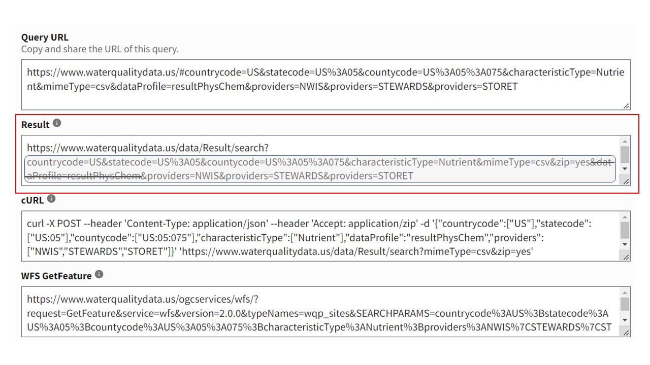
a. Construct a similar query in the Advanced form of the Water Quality Portal website. From the Results box containing the URL, copy and paste the parameters and argument values into your summary service query, excluding the dataProfile parameter-argument pair, which differs from the dataProfile options for the summary web service. Below is an example screenshot from the Water Quality Portal. The shaded area denotes the section that can be copied and pasted into the summary service URL. The crossed out section indicates the dataProfile, which should be replaced with one of the two allowable options for the summary service, as mentioned above and in Table 2.
 b. Download the full list of allowable parameter values, available on a per-parameter basis. Links are provided in Table 2.
 -
Use caution when specifying a parameter that is nested within another parameter (e.g. characteristicName and characteristicType; county and state). Queries that combine nested parameters can lead to unexpected behavior, particularly when more than one argument for one or more parameters is specified. Combining nested parameters with multiple arguments for a given parameter is therefore not recommended. For example, the following query parameters used in combination may not produce the expected result:
characteristicType=Nutrient&characteristicType=Physical&characteristicName=Nitrogen&characteristicName=Temperature
Using Open Geospatial Consortium Services to map Water Quality Portal sites based on Water Quality Portal Parameters
The Water Quality Portal has an endpoint for generating OGC-Compliant Geospatial web services. At this time, Web Mapping Service (WMS) version 1.3.0 and Web Feature Service (WFS) version 2.0.0 are supported. The service is a customized version of the WMS and WFS services provided by Geoserver. To get started, check out the Geoserver WMS Reference and WFS Reference.
The base URL for both the WMS and WFS services is:
https://www.waterqualitydata.us/ogcservices/{wms|wfs}
Use web mapping tools, such as Leaflet or Openlayers, to easily connect to these web map services. GIS tools such as ArcGIS and QGIS also connect to these web maps services.
WFS and WMS services require an additional parameter, called "SearchParams", which is a URL-encoded version of the WQP search parameters. The service supports calls up to up to 250,000 sites. Calls that return large numbers of sites will take longer to load for the first time, as a cache is populated; subsequent responses will be much quicker. The cache is cleared after new data are loaded to the portal (once a day, at night).
At this time, we support WMS GetMap, WMS GetFeatureInfo, and WMS GetLegendGraphic.
WMS Getmap
- For detailed information on constructing a WMS getmap request, refer to the GetMap documentation at the Geoserver site.
- Here is an example GetMap Request for stream sites that have samples for atrazine:
https://www.waterqualitydata.us/ogcservices/wms?SERVICE=WMS&REQUEST=GetMap&VERSION=1.1.1&LAYERS=wqp_sites&STYLES=wqp_sources&FORMAT=image%2Fpng&TRANSPARENT=true&HEIGHT=256&WIDTH=256&SEARCHPARAMS=countrycode%3AUS%3BcharacteristicName%3AAtrazine&SRS=EPSG%3A3857&BBOX=-15028131.257091932,-7.081154551613622e-10,-10018754.171394622,5009377.085697313
Looking Up Domain Values Through Web Services
The allowable values for each query variable (referred to as domain values) may change over time as new values are added. There is a web service request that allows you to look up which values are allowed for a query parameter.
A list of parameter names and arguments to use for these web service requests is shown in Table 3.
Base URL for looking up domain values: https://www.waterqualitydata.us/Codes/{endpointName}?{parameter}
You must provide at least one argument in the web service call. If you want all domain values, you can just specify the mimetype (e.g. mimeType=json).
Table 3. Domain values web service parameters and arguments
Expand Table
| {endpointName} | REST parameter | Argument | Discussion | Example |
|---|---|---|---|---|
| Common parameters for all domain values web services | mimeType | xml|json | returns either XML or json. Default is xml | https://waterqualitydata.us/Codes/characteristicname?text=ph&pagesize=20&pagenumber=1&mimeType=json |
| pagenumber | page number (1,2 etc) | allows for results to be paginated (especially useful for endpoints with many valid responses, allows for infinite scrolling). Use along with pagesize | ||
| pagesize | e.g. 20 | number of results to return per page | ||
| text | e.g. ph | text to match to endpoint results. This is straight string matching. When the text parameter is used, the results are returned sorted by length | ||
| Endpoints with unique query parameters in addition to common query parameters | ||||
| countrycode | FIPS country codes | |||
| statecode | countrycode | A FIPS country code (e.g. US) | FIPS state codes. A FIPS country code argument is appended so that the URL ends as /statecode?countrycode=US | https://www.waterqualitydata.us/Codes/statecode?countrycode=US |
| countycode | statecode | A FIPS statecode (e.g. statecode=US:01;US:04) | FIPS county codes. A FIPS statecode argument is appended so that the URL ends as /countycode?statecode=US:01;US:04 | https://www.waterqualitydata.us/Codes/countycode?statecode=US:01;US:04 |
| Sitetype | Available site types | https://www.waterqualitydata.us/Codes/Sitetype?mimeType=json | ||
| Organization | Available organization IDs | https://www.waterqualitydata.us/Codes/Organization?mimeType=xml | ||
| Samplemedia | Sample media | https://www.waterqualitydata.us/Codes/Samplemedia?mimeType=xml | ||
| Characteristictype | Characteristic types (groups) | https://www.waterqualitydata.us/Codes/Characteristictype?mimeType=xml | ||
| Characteristicname | Characteristic names. A good choice for using paginated results so that hundreds of results are not returned | https://www.waterqualitydata.us/Codes/Characteristicname?mimeType=xml | ||
| providers | The names of the Data Sources for the Water Quality Portal | https://www.waterqualitydata.us/Codes/providers?mimeType=xml |
Using ArcGIS Online to map Water Quality Portal Sites
Station data from the Water Quality Portal can be imported to ArcGIS Online. To get started, create a query using the Advanced form and copy the Station Web Service query at the bottom of the form.
Adding WQP Stations from the Web (New Map Viewer)
- In your ArcGIS Online account, Open the Map Viewer.
- Under the layers tab, open the add dropdown and select “Add layer from URL”.
- Paste the Station query you copied above into the URL field. You may add the layer as either a csv or GeoJSON but both should be imported as a non-zipped file.
- Edit the URL to read "mimeType=geojson&zip=no".
- Next, select the layer type as GeoJSON, then click next. You will be given the option of adding the layer to the map, or hosting the web layer in your content. For best results, larger queries should use the hosted feature layer option.
- Select “Add to Map”. The stations you queried should appear on the map.
Adding WQP Stations data from the Web (Classic Map viewer)
- In your ArcGIS Online account, Open a Classic Map Viewer.
- Click the “Add” dropdown and select “Add Layer from Web”.
- Select “A CSV File” from the file type dropdown and paste the WQP Station Query URL that was generated by your search.
- Edit the URL zip instructions to read “mimetype=csv&zip=no” and click the “ADD LAYER” button. A pop-up will ask you to identify the latitude and longitude fields in the data.
- Scroll down the data fields to correctly identify “LatitudeMeasure” and “LongitudeMeasure” as the respective fields.
- Select “ADD LAYER” again and the stations should appear in the map.
Example Station call (csv)
Here is an an example station call for all stations with data in Prince George County, Maryland: 'https://www.waterqualitydata.us/data/Station/search?countrycode=US&statecode=US%3A24&countycode=US%3A24%3A033&mimeType=csv&zip=no&providers=NWIS&providers=STEWARDS&providers=STORET'
Example Summary Service call (geojson)
Here is an example of a summary service call for a 5-year summary of all nutrient data in Baxter County, Arkansas: 'https://www.waterqualitydata.us/data/summary/monitoringLocation/search?countycode=US%3A05%3A007&characteristicType=Nutrient&zip=no&dataProfile=summaryMonitoringLocation&summaryYears=5&mimeType=geojson'
You can follow these same instructions to import any of the other WQP profile services, including the Result Service, Period of Record Service, or Station Summary Service simply by following the same conventions of mimetype and zip=no. You can find additional information for building calls in our web services documentation above.
Note, currently all csv and geojson calls are supported in the New Map Viewer. In the Classic Map Viewer, you cannot add a geojson from the map, but may still import a hosted geojson feature service, and while you may import a csv directly into the map, there is no service to host a csv.